

New Government data show most Dorset village housing sites unsuitable
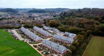
Dorset Council consulted local people last Autumn about potential sites on which to build the Government’s target of 55,000 new homes in Dorset over the next 17 years. That target is around twice the number which recent ONS household projections suggest is actually needed, could expose our communities to speculative development and puts nature at risk. Nearly 20,000 homes were proposed on sites in or around Dorset villages – the so-called Tier 3 villages with 500 residents or more. Now new Government data show that almost all those village sites are not suitable.
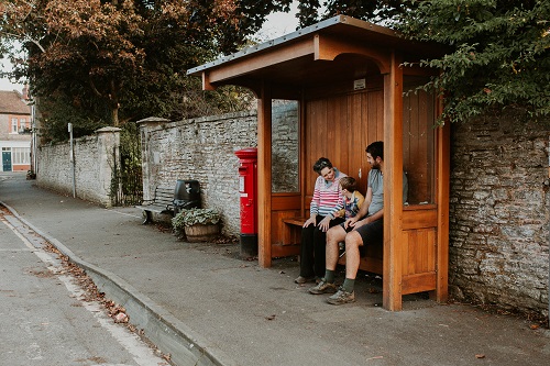
The consultation responses are still being analysed, but it’s fair to say that thousands of villagers’ views will be negative. One important reason is that they know Dorset’s villages are not well-connected to the services they need nor the places they want to visit. People accept that most of their journeys need a car, but can’t see the logic of expanding that massively in an age when sustainability has become important.
Connectivity Tool
Car travel cannot continue to increase at the rate proposed. Our inadequate roads and junctions are often clogged, air quality is compromised by traffic pollution, and fossil fuels are problematic. Helpfully the Government has created a Connectivity Tool to evaluate sites by how well they are connected to the places people need to or want to visit by walking, cycling or using public transport. Destinations include work places, friends, schools, shopping, leisure and healthcare. The data set is enormous, including every timetable, road and footpath, plus a myriad of evidence from surveys. Every 100m square (hectare) in England and Wales is scored: the most connected places – big city centres – score 100. Weighted by population the national average is 67. The average overall in Dorset is low at just 46, despite the main Dorset town centres scoring in the 60s and 70s.
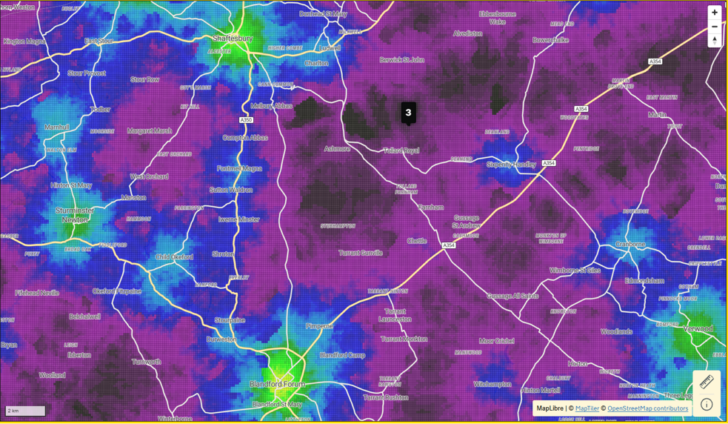
For the first time, planners (and the public) are able to compare sites to see where the better places are for connectivity and reducing car travel. The Dorset data show exactly what people in the Tier 3 villages would expect:
- Forty-five of those fifty-four villages score in the bottom 10% of places in England and Wales (scoring below 39).
- Most of the villages score below Dorset’s overall average of 46.
- Therefore the Council’s Options Consultation proposes building nearly 20,000 homes in villages that, if actually built, would all decrease the average connectivity in Dorset. Such sites are not sustainable.
This would be an alarming plan for a Council committed to a sustainable future. Of course some new building in those villages is needed, but not at the scale proposed. Surely both Dorset Council and the Government must accept that such sites – with poor connectivity below Dorset’s current average – should not be chosen for large scale development?
Dorset CPRE supports our communities in wanting a balanced Local Plan for the right housing in the right places, including the truly affordable homes that Dorset needs. We all want a thriving, successful, sustainable future for Dorset’s communities, economy and countryside – at a sensible scale.
| Tier 3 settlement | Population† | Area | Connectivity score | Homes proposed |
| Milton Abbas | 722 | central | 15 | 60 |
| Hazelbury Bryan | 1025 | northern | 19 | 299 |
| Bishop’s Caundle | 496 | northern | 21 | 301 |
| Okeford Fitzpaine | 805 | northern | 22 | 177 |
| Broadmayne & West Knighton | 1517 | central | 23 | 1170 |
| Charlton Down | 1472 | central | 24 | 220 |
| Sixpenny Handley | 930 | SE | 24 | 107 |
| Thornford | 854 | northern | 25 | 179 |
| Milborne St Andrew | 1031 | central | 27 | 342 |
| Mosterton | 615 | western | 27 | 59 |
| Bere Regis | 1508 | SE | 28 | 196 |
| Bourton | 844 | northern | 28 | 125 |
| Fontmell Magna | 483 | northern | 28 | 105 |
| Winterbourne Abbas & Winterbourne Steepleton | 604 | central | 29 | 50 |
| Shillingstone | 1186 | northern | 30 | 175 |
| Broadwindsor | 554 | western | 30 | 89 |
| Maiden Newton & Higher Frome Vauchurch | 1158 | central | 30 | 46 |
| Yetminster | 1093 | northern | 31 | 200 |
| Cranborne | 606 | SE | 31 | 87 |
| Winterborne St Martin (Martinstown) | 576 | western | 31 | 40 |
| Puddletown | 1239 | central | 33 | 258 |
| Burton Bradstock | 880 | western | 33 | 119 |
| Child Okeford | 1119 | northern | 33 | 105 |
| Sturminster Marshall | 1567 | SE | 34 | 1861 |
| Motcombe | 1077 | northern | 34 | 464 |
| Marnhull | 1889 | northern | 35 | 697 |
| Crossways & Moreton Station | 2451 | central | 36 | 4697 |
| Lytchett Matravers | 3163 | SE | 38 | 472 |
| Charmouth | 1371 | western | 40 | 152 |
| Charminster | 1519 | central | 41 | 560 |
| Lytchett Minster | 244 | SE | 42 | 5446 |
| Wool & East Burton | 2653 | SE | 51 | 855 |
| Totals | 37,251 | 19,713 |
(†populations taken from https://www.dorsetcouncil.gov.uk/documents/35024/290430/DCLP-Jan-2021-settlement-hierarchy.pdf#page=26)